Search

Lightweight, RTK-ready precision mapping for utility locating and underground asset documentation
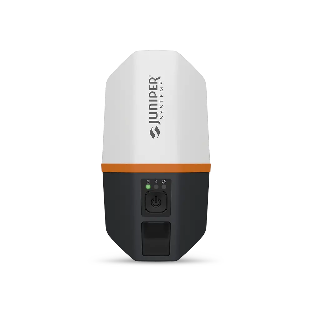
The Juniper Spire is a lightweight, multi-frequency GNSS receiver engineered to deliver real-time centimeter-level positioning for utility locating, asset inventory, and underground infrastructure mapping. Tracking the GPS, GLONASS, Galileo, BeiDou, QZSS, and NavIC constellations across the L1, L2, and L5 frequency bands, it resolves accurate positions quickly and holds them in obstructed-sky conditions where single-frequency receivers lose reliability. At under 12 ounces, with an integrated helical antenna and one-button operation, it connects over Bluetooth to the tablet or smartphone your crews already carry, providing survey-style data without the weight, cost, or setup of a conventional receiver.
Green Equipment Company supplies and supports the Spire across our eight-state territory, backed by the in-person training, hands-on delivery, and factory-authorized service that have defined our work since 1978. Below is a full technical overview of the receiver, the field workflows it fits, and the questions buyers ask most before adding it to their fleet.
Survey-grade receivers deliver accuracy, but they tend to be heavy, costly, and slow to set up in the field. The Spire is engineered to remove that overhead. As Juniper Systems' lightest receiver to date, it integrates the antenna into the housing and eliminates external cables and complex configuration, allowing a single operator to run it on a range pole or backpack mount through a full shift. The result is dependable, professional-grade positioning in a form factor built for daily field use.
That portability does not limit performance. The Spire's multi-frequency, multi-constellation engine acquires satellites quickly and maintains a stable position fix in difficult signal environments: under tree canopy, alongside buildings, and within the constrained sightlines common to developed utility corridors.
Not every task needs the same precision, and the Spire lets you choose the correction method that matches the work in front of you. It is ready for satellite-based and network corrections straight out of the box, so accuracy scales from sub-meter to centimeter without swapping hardware.
• SBAS for everyday mapping. Using SBAS corrections, the Spire delivers positioning better than 70 centimeters, ideal for general asset inventory, condition surveys, and feature collection.
• Network RTK for high-precision work. Connected to an RTK network through the Juniper RTK service, the receiver achieves roughly 1.5 to 2 centimeters of horizontal accuracy, the precision needed for mark-out verification, as-built records, and survey-style point capture.
• Ready for what comes next. The Spire is designed to accept additional correction services over its lifetime, protecting your investment as your accuracy requirements grow.
Because corrections are delivered over the internet through your paired device, there is no separate base station to set up or radio link to maintain. A crew can arrive on site, connect, and begin collecting accurate points within minutes.
Equipment that fails in the field costs far more than its purchase price. The Spire carries an IP68 rating, meaning it is fully sealed against dust and capable of withstanding water immersion, which is important across the heat, humidity, and sudden downpours common throughout the Gulf and South Central states. It is also tested to MIL-STD-810H for shock and vibration and rated to operate from -20 °C to +60 °C, so it performs whether it is riding in a truck bed through a Texas summer or working a job site after a cold front.
This is the kind of durability our customers expect from a tool they will lean on every day, and it is backed by Green Equipment Company's factory-authorized repair center if service is ever needed.
The Spire is a bring-your-own-device receiver. It connects over Bluetooth to Windows 10 and 11 tablets, Android devices, and Apple iPhones and iPads, which means you are not locked into a single proprietary controller or forced to retrain your team on unfamiliar hardware.
On the software side, the Spire feeds position data into the mobile mapping applications that GIS and utility teams already rely on, including Esri ArcGIS Field Maps, Survey123, and SW Maps. Juniper's own Juniper Connect utility handles receiver setup, status, and correction configuration. The practical upshot is a short learning curve: if your crew can run a mapping app today, they can run the Spire.
For most of our customers, the Spire is not a standalone survey tool; it is the mapping half of a complete damage-prevention process. A locate tells you where a line is; the Spire records where it is, accurately enough to act on later. Pairing the two closes the loop between finding utilities and documenting them.
As your crew traces a gas main, water line, or buried cable with a locator, the Spire logs each point or run directly into your GIS at the same time. There is no transcribing flag positions onto paper or estimating coordinates back at the office.
Centimeter-level RTK positions create records that hold up, which is useful for 811 ticket documentation, post-construction as-builts, and resolving disputes about what was marked and where.
Every point the Spire collects becomes part of a growing, reliable map of your underground network, supporting maintenance planning, future excavation, and infrastructure upgrades.
The Spire fits naturally into the industries Green Equipment Company serves every day:
• Gas utilities: Mapping mains and service lines, verifying mark-outs, and recording new installations.
• Municipal and water/wastewater: Documenting water, sewer, and stormwater assets for public works and GIS departments.
• Telecom and CATV: Recording buried communication and coaxial cable runs after locating.
• SUE and engineering: Capturing utility positions during subsurface utility engineering surveys and pre-design data collection.
• Directional drilling and excavation: Confirming and logging utility locations before boring or trenching begins.
• Environmental: Collecting georeferenced data for monitoring, compliance, and site assessment.
The following specifications summarize the Spire's core capabilities. Exact figures can vary with correction source, satellite visibility, and environmental conditions; our team can confirm details for your specific application.
The Spire ships as a complete, field-ready kit (configuration SP1-CFG-1457, Spire GNSS Receiver US/NA/EU with Charger). Your crew can charge it, pair it, and start collecting without sourcing any additional parts:
Pricing is provided by quote. Contact Green Equipment Company for current pricing and availability.
What accuracy can the Juniper Spire achieve?
The Spire provides better than 70-centimeter accuracy using SBAS corrections and approximately 1.5 to 2 centimeters when connected to an RTK network through the Juniper RTK service. You select the correction method based on how precise the task needs to be.
Do I need a special data collector to use the Spire?
No. The Spire is a bring-your-own-device receiver that connects over Bluetooth to Windows 10/11, Android, and iOS devices. You can use tablets and smartphones your crews already own.
Which mapping apps work with the Spire?
It works with common mobile mapping and GIS applications, including Esri ArcGIS Field Maps, Survey123, and SW Maps. Juniper Connect handles receiver configuration and correction setup.
Does the Spire need a base station or radio for RTK?
No. RTK corrections are delivered over the internet through your paired device using a network correction service, so there is no separate base station to set up or radio link to manage.
Is the Spire rugged enough for daily utility work?
Yes. It is IP68 rated against dust and water, tested to MIL-STD-810H for shock and vibration, and rated to operate from -20 °C to +60 °C, making it well-suited to demanding outdoor field conditions.
How long does the battery last?
The Spire is built for full workdays, providing up to 20 hours of continuous use on a single charge.
How is the Spire different from heavier survey receivers?
It delivers comparable real-time positioning accuracy in a far lighter, simpler, and more affordable package. At under 12 ounces with one-button operation and no external antenna, it is built for crews who need precise data quickly rather than a full survey-instrument setup.
Can Green Equipment Company help us get started with the Spire?
Absolutely. We provide hands-on delivery, comprehensive classroom and field training, assistance with crew onboarding, and factory-authorized repair service throughout our eight-state territory.
Ready to add precision mapping to your locating workflow?
Salesman – Luis Hernandez
Cell: 210-410-7589
Fax: 210-568-6451
Salesman – Jimmy Fougerousse
Cell: 817-247-5039
Fax: 469-362-9112
Salesman – David Plummer
Cell: 713-542-9944
Fax: 713-568-2471
Salesman – Brandon Baker
Cell: 817-307-0808
Fax: 817-284-1107
Salesman – Jason Crowe
Cell: 918-691-4360
Fax: 918-516-0563
Salesman – John Neely
Cell: 505-999-0753
Salesman – Donald Love
Cell: 225-281-8286
Fax: 225-612-6740
Salesman – Dan Kemper
Cell: 352-428-7582
Fax: 352-799-9779
Salesman – Jason Wiley
Cell: 205-565-9265
Fax: 205-278-8742
Salesman - Damion Kemper
Cell: 352-428-8363