Search

A rugged Android data collector and RTK-capable mapping platform for utility damage-prevention workflows
Starting at $1,480 (USD) · Volume discounts available · Financing options · Call 1-800-391-7612 for a quote
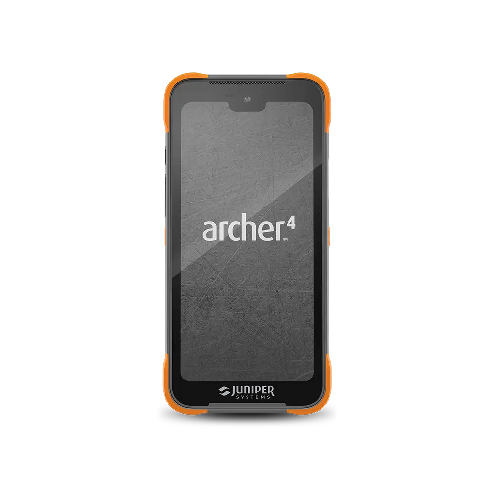
The Juniper Systems Archer 4 is a rugged Android handheld computer engineered for accurate field data collection and GIS mapping. In utility damage-prevention work, it serves as the field platform that records and maps located infrastructure, capturing line position, depth, material, condition, and photo documentation, then transferring that data directly to your geographic information system. Locating, gas, municipal, pipeline, and directional-drilling teams across the Gulf South rely on the Archer 4 to convert field locates into accurate, durable records.
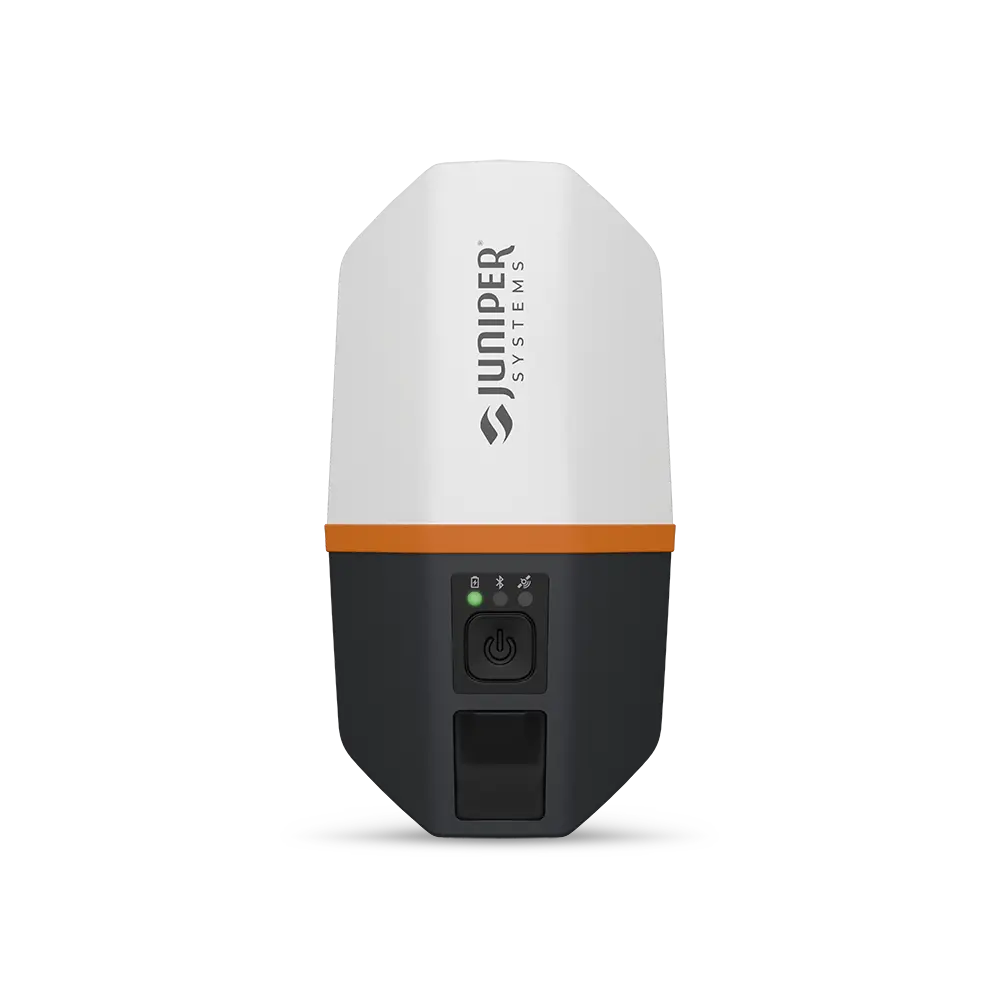
Built to operate reliably in the varied climates and soil conditions of outdoor utility work, the device protects data integrity across temperature extremes, moisture, and debris. Paired with the A4 GNSS Expansion Pod, it becomes a multi-constellation RTK mapping receiver, delivering centimeter-level positions suitable for as-located mapping, subsurface utility engineering (SUE), and GIS asset management.
– Enterprise-class processing. A Qualcomm QCM4490 octa-core processor (up to 2.4 GHz) with 8 GB of RAM sustains responsive performance across mapping, imaging, and forms-based data entry. Juniper specifies manufacturer support through at least 2030, protecting the device against premature obsolescence.
– Android 16 with a defined upgrade path. The Archer 4 ships on Android 16 with support for upgrades through Android 18, and is Google Mobile Services (GMS) certified — ensuring compatibility with standard field data-collection and GIS applications throughout its service life.
– Scalable GNSS accuracy. Integrated dual-band GNSS provides navigation-grade positioning out of the box. Adding the A4 GNSS Expansion Pod and an RTK network correction scales accuracy to the centimeter level for survey-grade utility mapping.
– All-day, hot-swappable power. Selectable 4,500 mAh or 8,300 mAh batteries provide up to 18 hours of runtime and are temperature-optimized for field use. Hot-swapping replaces a depleted pack without powering down or interrupting an active session.
– Sunlight-readable, wet-capable display. A 6.26″ FHD+ (2280 × 1080) capacitive touchscreen under Corning Gorilla Glass 5 remains legible in direct sunlight and responsive to wet or gloved input.
– Field-to-office connectivity. 5G cellular (with 4G LTE fallback), Wi-Fi 6E, and Class 1 Bluetooth 5.2 support real-time data synchronization to the cloud, to office GIS, and to paired field accessories.
The Archer 4 carries an IP68 rating against dust ingress and water immersion and is validated against MIL-STD-810H environmental test procedures rather than general durability claims. Verified methods include:
Low pressure (500.6) · high temperature (501.7) · low temperature (502.7) · temperature shock (503.7) · rain (506.6) · humidity (507.6) · sand and dust (510.7) · immersion (512.6) · vibration (514.8) · shock (516.8).
The enclosure operates across a temperature range of –20°C to 50°C (–4°F to 122°F), and Juniper-signature protective bumpers absorb the impact loads that typically retire consumer-grade devices. The result is consistent operation in rain, dust, vibration, and immersion conditions common to excavation and locating environments.
The Archer 4 is a data-collection and mapping platform, not a line locator; it completes the locate by documenting it. Field crews trace and depth the utility with their existing locating equipment, then use the Archer 4 to record position, attributes, and imagery and to map the asset in the field. This produces a defensible, georeferenced record in place of transient surface marks.
– Software-agnostic mapping. The device runs Juniper Uinta, Esri ArcGIS Field Maps, and standard Android GIS applications, so field data flows directly into existing office systems, coordinate references, and asset schemas.
– RTK precision via network corrections. With the A4 GNSS Expansion Pod and Archer Connect, the unit connects to RTK correction networks to deliver repeatable centimeter accuracy, capturing survey-grade points in fewer passes and reducing rework.
– Modular expansion. Snap-on expansion pods add capabilities to a single platform, a GNSS pod for high-accuracy positioning, or a 1D/2D barcode imager for asset and inventory identification, alongside a full range of field-ready mounts and vehicle cradles.
Green Equipment Company has served the damage-prevention industry since 1978, supporting utilities and contractors across Texas, Louisiana, New Mexico, Mississippi, Oklahoma, Alabama, Arkansas, and Florida. As problem solvers who represent world-leading manufacturers, we back every Archer 4 with hands-on service that keeps field crews productive after the sale.
– Free, comprehensive training. Classroom and field training is included with delivery, with continued support for safety meetings and new-hire product instruction.
– Hand delivery and setup. Most equipment is hand-delivered and configured with your team, so the device is field-ready on day one.
– Factory-authorized repair. Service and calibration are performed in-house at our authorized repair center, minimizing downtime and third-party hand-offs.
– Flexible financing. A 60-second application returns competing offers from leading equipment lenders, aligning acquisition with your budget cycle.
Is the Archer 4 a utility locator?
No. The Archer 4 is a rugged Android handheld computer, not a transmitter or signal receiver. It complements the pipe-and-cable locator your crew already operates: the locator traces and depths the line, and the Archer 4 records position, depth, material, and imagery, then maps the asset to your GIS.
What positioning accuracy can the Archer 4 achieve?
Accuracy is scalable. The integrated dual-band GNSS provides navigation-grade positioning. With the A4 GNSS Expansion Pod, a u-blox F9P multi-band, multi-constellation receiver, accuracy ranges from sub-meter in standalone mode to roughly 2 cm when connected to an RTK correction network through Archer Connect, suitable for as-built and SUE-grade deliverables.
Which GNSS constellations and corrections does it support?
The GNSS Expansion Pod tracks GPS, GLONASS, Galileo, and BeiDou, with SBAS and QZSS augmentation. Real-time kinematic (RTK) corrections are delivered over an RTK network connection managed in Archer Connect, yielding approximately 1 cm + 1 ppm positioning under network corrections.
Which operating system does it run, and how long is it supported?
It ships with Android 16 and supports upgrades through Android 18, and is GMS-certified for Google Play applications. Its enterprise-class Qualcomm processor is specified for manufacturer support through at least 2030.
How rugged is the device, and what is its temperature range?
The Archer 4 is IP68-sealed against dust and water immersion and is validated to MIL-STD-810H procedures covering drop, vibration, temperature extremes, rain, humidity, immersion, and sand and dust. It operates from –20°C to 50°C (–4°F to 122°F), with a Gorilla Glass 5 display and protective bumpers for jobsite durability.
Will it integrate with our existing locators and GIS?
Yes. The Archer 4 is locator-agnostic and runs standard Android data-collection software, including Esri ArcGIS Field Maps and Juniper Uinta, so it fits the locating equipment, coordinate systems, and asset schemas your operation already uses.
What does the Archer 4 cost, and how do we order?
Pricing starts at $1,480 (USD), with volume discounts and financing available; the GNSS Expansion Pod is offered separately or as a bundled mapping configuration. Contact Green Equipment Company at 1-800-391-7612 or request a quote, and we will specify the appropriate handheld, battery, and GNSS options for your application.
See how the Archer 4 fits your damage-prevention workflow. Call 1-800-391-7612, request a quote, or schedule a free on-site demonstration with the Green Equipment Company team.
Salesman – Luis Hernandez
Cell: 210-410-7589
Fax: 210-568-6451
Salesman – Jimmy Fougerousse
Cell: 817-247-5039
Fax: 469-362-9112
Salesman – David Plummer
Cell: 713-542-9944
Fax: 713-568-2471
Salesman – Brandon Baker
Cell: 817-307-0808
Fax: 817-284-1107
Salesman – Jason Crowe
Cell: 918-691-4360
Fax: 918-516-0563
Salesman – John Neely
Cell: 505-999-0753
Salesman – Donald Love
Cell: 225-281-8286
Fax: 225-612-6740
Salesman – Dan Kemper
Cell: 352-428-7582
Fax: 352-799-9779
Salesman – Jason Wiley
Cell: 205-565-9265
Fax: 205-278-8742
Salesman - Damion Kemper
Cell: 352-428-8363